1. Introduction
When observed geospatially and geographically, Bosnia-Herzegovina and Croatia present a puzzle-fit block which shares considerable linking elements and very challenging to demarcate and separate without compromising the strategic and security considerations of both elements. Even though the land-border has been one of the longest-established borders in Europe, and at times heavily militarized, its geomorphological complexity, overall length and variety of political factors are a continuing challenges for the overall border security and cross-border cooperation. In the second decade of the 21st century, the border is becoming another flash-point for trans-national migrations (and associated trans-national crime), but also as a potential “weakness exploit” within larger concepts of hybrid-warfare between NATO and increasingly assertive Russian Federation. This paper is outlining some of the lessons learned from the trans-border challenges in the zones of frozen conflict and the current set of challenges facing the border region between Bosnia-Herzegovina and Croatia.
2. Historical Background
The current borders of Croatia and Bosnia-Herzegovina represent some of the oldest standing borders in Europe stemming from over 350 years of Habsburg-maintained military frontier zone along the southern and eastern borders of Croatia. The principal purpose of this creation was to present a defensive perimeter against Turkish incursions, but also upon all other “external threats” of the Habsburg sphere of interest (Rothenberg G., 1960). As it stood, the military-border command authority became the de-facto and de-jure ruler of the realm, while the population was regimented and organized into defensive formations that could be called upon moment’s notice, anywhere along the border and within pre-positioned fortifications, making it probably one of the most successful organizations in the Habsburg Empire. The military border organization, was also used as a justification for the “mission continuity” of the continued German-Austrian military strategy, involvement and intervention in the Balkans leading up to the 1st World War (Rothenberg G., 1964). A similar-organization of military-administration was implemented on the opposite-side in the military organization of the Ottoman Empire through the system of core and auxiliary troops, fortifications and integrated system of military borders, relying on the appointment of captains and noblemen to semi-autonomously administer the fluid western border of the Ottoman Empire (Bougarel, 1999). This historical flashpoint legacy is reflected up to the present day, with a notion that the fault-lines inherited from the shifting borders, adventurism, loose-administration and banditry aimed against the opposing empire(s), have also contributed to the flashpoint igniting the Yugoslav Wars, starting with the 1990 uprising in the Krajina Region of Croatia (Pavlakovic, 2013).
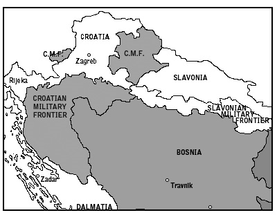
Figure 1. Croatian Military Frontiers map between the Ottoman and Habsburg Empires, middle 19th century (circa 1868).
3. Problematics
The current set of problems in the border region can be divided into two broad categories: socio-political, revolving around the problems of mass-migrations and the ability to stem or process large volumes of third-country nationals (TCN) and geospatial-technical, revolving around the problems of being able to monitor the wide-swaths of border using technological advances. Both problems, in essence stem from the same limitations: manpower and resources; there is a finite (and dwindling) resource pool available that can be tasked towards successfully managing border challenges, short of militarizing it. However, even the heavy-handed and militaristic approach to border security is bound to back-fire and present additional problems (Massey, et al., 2016).
3.1 Socio-political Elements
The current mass-migration crisis is in full swing in the Western Balkans since 2015, but exacerbated by the closing of the Hungarian border in 2016 and the subsequent State of Emergency still in force. The Western Balkans migration route was and still remains as an only semi-viable pathway for the massive influx of migrants from the Middle East and Africa. According to the United Nations, 80% of the almost one million refugees that found shelter in Germany in 2015 passed through this route by either registering at the Presevo Refugee Center in Serbia (600,000) or bypassing it and moving on through Bosnia-Herzegovina, into Croatia and beyond (Cocco, 2017). The issue was further complicated by Serbia’s liberal visa regime with the several developing nations including Iran (Lakic, 2018) resulting in significant numbers (est. 23,000 since 2018) of migrants seeking to enter EU via Bosnia-Herzegovina and Croatia (Kalan, 2019). The influx of people have overwhelmed the capabilities of Bosnia-Herzegovina in both protecting of its own porous border with Serbia and Montenegro, but also stopping migrants from crossing over to Croatia and/or providing them with viable settlement and shelters during the transit or adjudication process. The illicit activities that enable migrations (smuggling) or seek to undermine the thin veneer of system in an otherwise heavily paralyzed country such as Bosnia-Herzegovina have increased considerably in the last 24 months (Europol, 2019).
Table 1. Unofficial field reports of migrants encountered in Bosnia-Herzegovina from
2017 – 2019 by the countries of origin, ranked in a descending order (BH-SPS, 2020).
|
ORIGIN |
2017 |
2018 |
2019 |
TOTAL |
|
Pakistan |
66 |
7,820 |
9,806 |
17,692 |
|
Afghanistan |
26 |
2,777 |
4,093 |
6,896 |
|
Syria |
32 |
3,034 |
2,131 |
5,197 |
|
Iran* |
28 |
3,607 |
1,180 |
4,815 |
|
Iraq |
4 |
2,187 |
2,471 |
4,662 |
|
Bangladesh |
2 |
452 |
2,144 |
2,598 |
|
Morocco |
19 |
269 |
2,221 |
2,509 |
|
Algeria |
91 |
477 |
1,601 |
2,169 |
|
Libya |
7 |
883 |
354 |
1,244 |
|
Palestine ** |
-- |
743 |
362 |
1,105 |
|
Other |
36 |
1,653 |
2,939 |
4,628 |
|
|
TOTAL |
53,515 |
||
|
* During 2017-18, Republic of Serbia had a visa-free arrangement with the Islamic Republic of Iran, resulting in an influx of Iranian nationals using Serbia as a jump-off point for entering EU via Bosnia-Herzegovina (OSCE, 2018). ** Government of Bosnia-Herzegovina recognizes “Palestine” as a nation, based on the bilateral agreement dated May 27, 1992. |
||||
Table 2. Unofficial field reports of asylum applications in Bosnia-Herzegovina (BH-SPS, 2020).
|
Migrants |
2017 |
2018 |
2019 |
TOTAL |
|
Registered |
311 |
23,902 |
29,302 |
53,515 |
|
Asylum Applicants* |
311 |
22,499 |
27,769 |
50,579 |
|
* Many migrants register and formally seek asylum in order to receive basic aid, legal status and medical assistance in the transit countries (OSCE, 2018) |
||||
3.1 Geospatial Technical Elements
The border between Bosnia-Herzegovina and Croatia encompasses variety of geomorphological areas, from high-alpine to low-land riverine, but with over 70% of it encompassing poorly-populated and undeveloped areas. Drastic elevation changes, heavy vegetation cover, incised topography and road-less areas present a considerable challenge in border surveillance, communication (especially line-of-sight), rapid response and terrain traffic as well as overall ability to detect, identify and apprehend any elements crossing the border illegally. Until recently, both Croatia and Bosnia-Herzegovina have considerably lagged in having a stable, digital geospatial baseline including topographic, land-use, land-cover and cadastral databases. With Croatia’s entry into EU, situation has been considerably improved, whereas Bosnia-Herzegovina still lacks even the basic-level geographic information system (GIS) / geospatial cover and networked communications (e.g. different police jurisdictions communicate on entirely different frequencies) as well as overall policing capabilities (Padurariu, 2014). Eastern and Western borders of Bosnia-Herzegovina are also administered by different political entities (Republic of Srpska (RS) Gendarmerie and Border Police of Bosnia and Herzegovina), with different levels of sophistication, command authority and overall capability. Only recently (2018), the Border Police started to use technical means to survey the border using electro-optical and thermal imagery in the areas of high-frequency crossings (Border Police of Bosnia and Herzegovina, 2019).
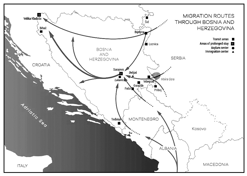
Figure 2. Migration routes through Bosnia and Herzegovina in 2017-19 period; adapted from CARITAS, December 11, 2019.
4. Borders and Frozen Conflict
The entire territory of Bosnia-Herzegovina remains in the state of a frozen conflict, where the return to hostilities, although unlikely, is always possible and that overall situation is overprinted upon the general situation at the border. The situation is similar to some other regions of frozen or simmering conflict, namely in Georgia, Moldova, Ukraine and Kosovo* from the standpoint that the central government may not have “complete” control of its borders. Granted, Bosnia-Herzegovina is not under occupation by the Russian military or paramilitary forces, however there are numerous reported incidents where the border integrity is put to stress (Secrieru, 2019). Russia largely considers the Western Balkans as a part of its greater strategy of reshaping and influencing the international order where hard-power is inadequate. It has demonstrated its capabilities in using hybrid and directed-force attacks through proxies to prevent states in its immediate neighborhood from joining NATO and the European Union (e.g. Georgia and Ukraine). As a long-standing rule, western institutions such as NATO deny countries with undefined borders membership, giving Russia (and its clients) ample reasons to wanting to undermine the borders of Bosnia-Herzegovina and the recent mass-migrations and influx of TCNs into an area may be one of the many tools at their disposal (Bajrovic, et al., 2018).
Undermining overall border integrity of Bosnia-Herzegovina could have potentially dangerous ramifications considering the diffuse nature, position and overall length of the border. Potentially hostile, uncontrolled border in Bosnia-Herzegovina could be strategically detrimental to NATO and EU because it opens almost a 1000 km long swath of border to potential incursion, intelligence-gathering, area-deniability and beyond, repeating the Habsburg-era scenario of a wild, militarized border.
5. Geospatial Considerations
Given the recent rapid growth in the availability and accessibility of near-real time geospatial datasets, it is possible to generate an up-to-date picture of the border regions. Available datasets may include:
- Satellite, Airborne and UAS-generated imagery
- Static feed imagery and radar data
- Data from unattended ground sensors or relay networks
- Real-time data (e.g. Google traffic data)
- Geographic Information Datasets (waterways, road networks, population centers)
- Cadastral and land-use data
- Weather and climate data
The largest hurdle is the volume and resources dedicated towards organizing, maintaining and using the data, however given the popularity of multi-layer data-visualization tools (even as simple as Google Earth), it allows the users to take full advantage of the available datasets.
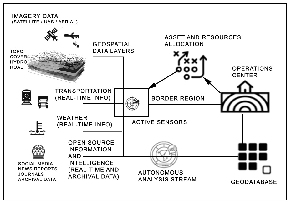
Figure 3. Geospatial data architecture for border surveillance
Different uses of geospatial data by border service could help maximize the lack of manpower and resources in monitoring the border by:
- Delineating land and coastal areas where clandestine crossings can be executed.
- Optimizing the deployment of any sensors (or personnel) at border areas;
- Correlating the destinations and movement of certain vehicles with illicit cargo occurrences (e.g. smuggling of people or goods)
- Optimizing patrols in insecure (or unpatrolled) areas of the border with a high level of reported incidents;
- Detecting bad practices and corruption at border posts by comparing traffic information provided by satellite (or other imagery) against official reports or statistics;
- Enhance information sharing between the two-countries aimed at curbing the problem through cross-border cooperation.
At least three mature technologies can be mobilized:
- Geographic Information Software (GIS) that collects and represents data in the form of map layers that can be independently or jointly analyzed and queried;
- Encrypted IT network infrastructure that enables the sharing of information and tools between a large pool of approved users who do not need to be located in the same place, within the perspective of regional cooperation;
- Mobile technology to facilitate the real-time transfer of data and the automation of their geo-location.
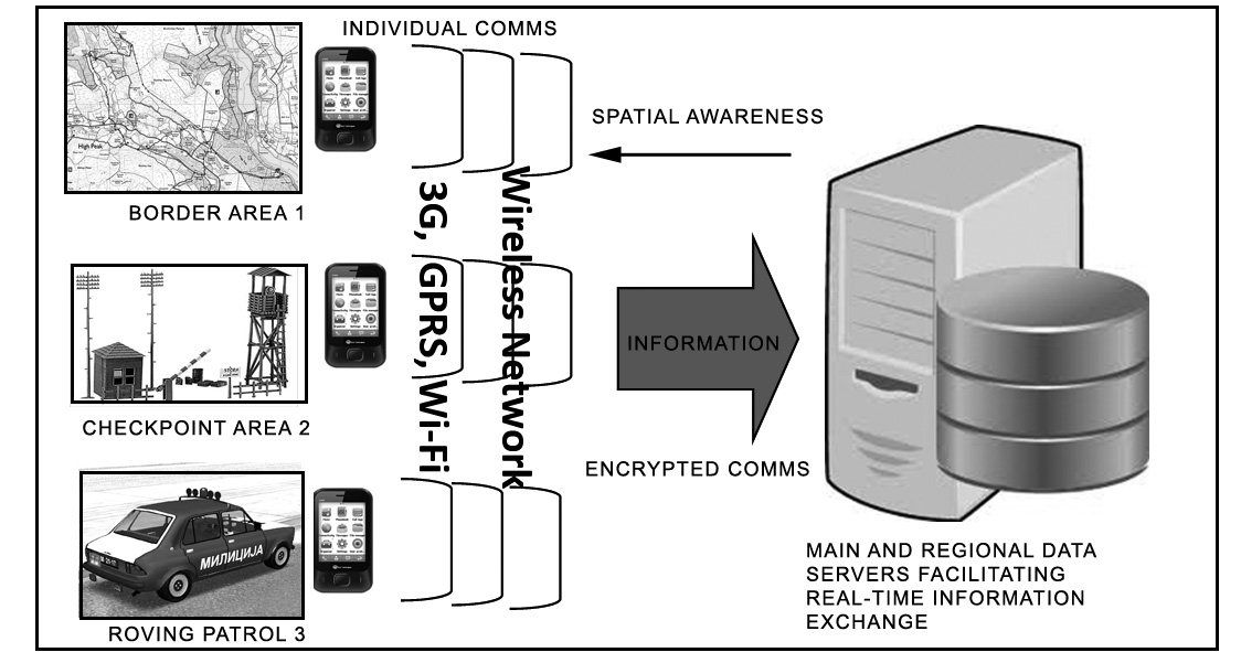
Figure 4. Encrypted networked communication for real-time data / information sharing.
These technologies can be used together or independently, depending on an administration’s needs and levels of expectation. Stand-alone GIS software can be used by intelligence units to visualize data and share analyses for operational purposes (GIS software integrates major statistics software). A spatial data infrastructure, combining the three technologies, can be imagined for an operation center collecting information and producing intelligence for the user groups.
6. Applicability on Bosnia-Herzegovina / Croatia Border
Just like the organization of the Military Border during Habsburg / Ottoman Empire was an all-encompassing, but relatively decentralized defensive network, a similar concept is therefore in a geospatial realm. The majority of the elements are already in place, however they need to be properly categorized and put into the operational use in a way that they are easy to adopt, execute and grow.
There are several underlying building blocks:
- Majority of the area has at least some level of underlying data-wireless network connectivity
- As a result of de-mining, war, relief and rebuilding operations, there are considerably-well mapped networks of roads, paths, border-crossings
- Cadastral data are fairly digitized and up-to-date
- Several consecutive land-cover studies (e.g. CORINE land cover data)
- Availability of free high-resolution satellite imagery at various sun-angle and vegetation (leaf on / leaf-off) conditions.
The above elements are sufficient to build the initial level of border surveillance and trafficability baseline that could help optimize the distribution of monitoring assets: focus the available resources only within the zones that are considered “permissive” for border crossing. The availability of underlying data and the presence of wireless network allows for the data to be shared and updated as the new information becomes available.
The baseline model can be refined and appended by additional data such as:
- Field reports and observations (increasing ranking of certain areas)
- Real-time surveillance (e.g. feed from cameras, aerial cameras, radars etc.)
- Current weather and water-flow reports (e.g. certain areas are impassable)
- Open-source data (e.g. news reports, social-media postings, tags etc.)
Based on the information above, a daily, monthly or seasonal risk portfolio can be generated and assets distributed in the area where they will make maximum effort. For example, in the wintertime with deep-snows and sub-zero temperatures, the likelihood of illicit border-crossings at Dinara region will be near zero, but at Slunj, the border crossings may be quite likely, suggesting that the available resources are dedicated to that locality; as the conditions change, the rankings and deployments can change.
7. Potential Scenarios
To demonstrate the potential applicability of geospatial architecture for border surveillance, two scenarios will be presented upon which certain elements can draw upon the existing and real-time information to formulate a proper response and dispatch the proper resources. Both scenarios are loosely based on the real-world events in Ukraine (Losh, 2016) and Hungary (Radio Free Europe, 2015) and the scenario developed to demonstrate tracking of a troublesome or diffuse group en-route to the border region, with some advance notice.
7.1 Scenario 1: Wolves in Krajina
Preamble: A group of Russian “bikers” has entered Bosnia-Herzegovina at Zvornik and is reportedly bound to Drvar area to block the settlement of migrant camp at Drvar. Their real mission is to test cross-border infiltration by fostering chaos, inciting migrant wave and disrupting communication; to that effect they are equipped with a broad radio-frequency and GPS jamming equipment.
Consideration elements: 1. Bikers can only operate in impunity within the road network of the RS Entity and are generally expected to stay within semi-improved roads, considering the type of bikes and tires recorded by camera upon their entry. 2. Clusters of migrants have been spotted between Drvar and border with Croatia; the biker’s likely target is to create a local disturbance aimed at the migrants 3. There are known communications relays at Srb and Osredci in Croatia and Kamenica in Bosnia-Herzegovina, which are likely targets of radio-frequency jamming. 4. Weather is expected to remain stable and warm for the duration of the month of June.
Geospatial cover: 1. The terrain around Drvar is fairly-rugged without many improved roads. 2. The current vegetation cover is fairly dense presenting good overhead cover. 3. Majority of the settlements on Bosnia-Herzegovina side are abandoned, while the population density is very light on the Croatian side. 4. Based on the last count of migrants based on the media reports and long-range aerial camera from the border drone-overflight, they are clustered in several groups of 30-40 individuals along the mountain roads. 5. Presence of Bosnia-Herzegovina law-enforcement is light to non-existent and the overall traffic is very light. 6. Presence of Croatian law-enforcement and border police is also very light as the majority are deployed elsewhere. 7. Closest force reaction areas are: Sibenik, Croatia (2 hours) and Bihac (2 hours); other small towns are insufficient to muster any significant or willing response.
Threat assessment: 1. Biker element is expected to arrive to Drvar within 6 hour envelope; they are expected to come to Drvar from the North. 2. There is no official response from the Government in Sarajevo on their status. 3. County (Canton) government in Bihac was expecting to form a road-block at the point where the bikers enter their jurisdiction near Kljuc. 4. Municipal government at Drvar and the ad-hoc Public Safety Committee have expressed their welcome and support to the Russian Bikers and have indicated that they will escort them to Drvar for a “hero’s welcome.” 5. Migrants as of yet are unaware of the current tensions brewing and may be caught in a confrontation and forced towards the border overwhelming the Croatian border services. 6. There are also considerable numbers of tourists at the Una National Park who could also be pulled or thrusted into the situation. 7. Russians are expected to use a full gambit of communications jamming capabilities and possibly cyber-operations involving a false-narrative or disinformation campaign.
Analysis: 1. Analysis of recent imagery suggest that certain forest roads in Republic of Srpska have been improved suggesting that the bikers will likely emerge at the Ostrelj pass and then move south towards Drvar, bypassing any roadblock by the authorities from Bihac. 2. Local supporters from the municipality of Drvar in conjunction with the Russian bikers will likely decide to drive out the several groups of migrants towards North and West along the main roads. 3. Russians are expected to jam majority of the available bands within the 10km envelope as the mass moves North. 4. Expected clash-point with the authorities from Bihac is likely to be at Martin Brod and Una National Park entrance where the maximum visibility and interaction with numerous tourists is also likely to be encountered. 5. Russian elements are expected to infiltrate in Croatia near Martin Brod using a volatile environment of Drvar locals, migrants, tourists, Bihac Canton authorities and/or possibly State officials from Bosnia as well as Croatia.
Recommendation: 1. Plan initial interdiction and sequestration of Russian bikers at Ostrelj before they reach Drvar. 2. Sequestrate migrant groups south of Drvar 3. Plan secondary blocking maneuvers on the main road leading out from Drvar towards Martin Brod. 4. Plan for alternate communications (e.g land-line) in case of Russian jamming. 5. Notify local media outlets for the possible influx of disinformation. 6. Place detection assets (cameras and any radars) on the paths leading towards the border to detect any attempt to breach the borderline.
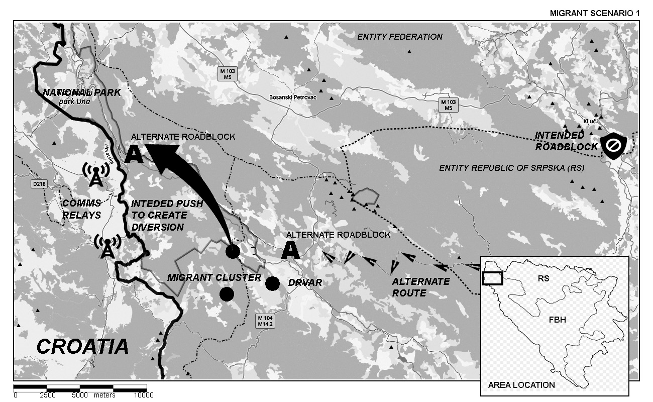
Figure 5. Scenario “Wolves in Krajina” situation map
7.2 Scenario 2: Tear Down This Wall!
Preamble: Approximately 3000 migrants (predominantly from Afghanistan, Pakistan and Bangladesh) are housed at the old agricultural complex near Velika Kladusa. Former poultry farm was barely adapted to house up to 500 migrants, but the arrival of winter had resulted in sudden increase of inmates. The migrants are becoming increasingly angry and desperate.
Consideration elements: 1. Approximately 1000 migrants are housed indoors while the remainder are housed in the make-shift ten city outside and precise numbers of male individuals are not known. 2. It is expected that the increasingly desperate migrants will break through the fence and dash for the Croatian border. 3. The overall numbers of border police on both sides of the border is currently inadequate to deal with the large influx of migrants. 4. Weather is expected to remain stable, but very cold with overnight temperatures reaching into -20 C.
Geospatial cover: 1. Recent high resolution satellite imagery of the migrant camp has been acquired and being analyzed for the approximate number of migrants 2. Current road network and cadastral maps give general indications of passable paths towards Croatian border and any abandoned objects that migrants may use as an interim shelter. 3. There are two commercial drones available that could follow the movement of any large migrant mass in real-time for approximately 75 minutes. 4. Weather data suggests that river Grabarska is largely frozen, while river Glina, forming the border between Bosnia-Herzegovina and Croatia is still flowing, albeit with lower volumes but water temperature near freezing.
Threat assessment: 1. It is expected that the migrants may attempt push en-masse toward Croatian border either West of Velika Kladusa or North near Maljevac border-crossing. 2. Westerly direction across relatively unpopulated plain is preferred option even though Croatia has erected certain amount of barriers. 3. Migrants may also disrupt regular border-crossing traffic at Maljevac and may attempt a break following the Glina river, where no barriers have been erected yet. 4. Current personnel is insufficient to successfully stem 5000+ migrants in reaching the border and eventually crossing it.
Analysis: 1. Based on the current movements and numbers, two groups of migrants are expected to move from the camp, the larger one is expected to move to the west and use relatively open land near the village of Smrekovac. Recent imagery suggests several clusters of trucks and vans clustering on the Croatian side of the border and they may be associated with the known groups that engage in migrant smuggling; it is possible that certain arrangements have been made with the groups in the camps. 2. Smaller group of migrants are also expected to move North through the City of Velika Kladusa; Recent drone imagery suggests that the local populace in Velika Kladusa may clash with the migrants seeking to disrupt normal traffic in Croatia. 3. Based on open-source reports, Croatia is mobilizing military forces to reinforce the existing barriers on the border.
Recommendation: 1. Place any available resources to stem and direct movement of migrants away from Velika Kladusa. 2. Assign all available resources to attempt keeping migrants within the camp or re-routed to another area south of the current compound from where they can be bused to other locations. 3. Should the containment operation fail, the flow of migrants should be slowed down and kept away from Croatian border to prevent escalation and potential violence; additional containment can be attempted along several rural roads. 4. Additional radar-and-camera cue detection systems can be placed along the Croatian border to alert any unauthorized crossings and interdict any link-up with the potential smugglers, whose presence has been detected.
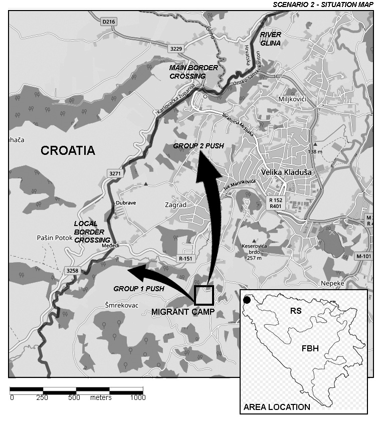
Figure 6. Scenario “Tear down this wall!” situation map
The scenarios presented above show on how input from various sources can be used to predict the possible pathways and developments of situation based on the array of possibilities a group may take. The role of geospatial elements is thus to act in the predictive modeling as a result of timely and accurate intelligence.
8. Discussion
During the heyday of the Habsburg and Ottoman Empires, the militarized border region was dependent on the network of fortifications, observation posts and around-the-clock ready militia forces that could respond to any incursion along the fortified border. Nowadays, border monitoring is taking advantage of the continuous stream of imaging, communications, open-source and other networked data to create a complete and coherent picture that could effectively note, track and respond to any crisis with any available resources. The primary advantage of the networked surveillance is the ability to consider several scenarios at once and adjust the response on how the situation develops in the field. Predictive modeling of the available information may alleviate shortcomings related to manpower, available resources, infrastructure and so on, allowing one to do more with less and over a wider area, setting the overall tone for its successful resolution (Kesetovic, et al., 2013).. The available technology is not revolutionary, but evolutionary allowing phased-in adoption, training and implementation over various aspects of border control, especially under fluid and rapidly evolving conditions. Variety of information can be properly categorized, evaluated and disseminated to the users that need it the most.
9. Conclusion
The presented framework of geospatial-aided information gathering and analysis in border surveillance and protection is based on a relatively mature technology that can be readily implemented and grown as additional resources or requirements are identified. In an inherently fluid, complex and evolving environment of border/near-border area, the ability to obtain, access and act-upon information received is very important for the overall time-to-decision is relatively short and often derived on an ad-hoc basis. The elements and scenarios presented above are sufficient to build the initial level of border surveillance understanding and overall monitoring baseline that could help optimize the distribution and implementation of any integrated surveillance network. The integrated network and decision-tree can enhance and focus the available resources within the zones that are flagged as problematic or permissive for the formation of any border incidents.
8. References
Bajrovic, R., Kraemer, R., & Suljagic, E. (2018, March 16). Bosnia on the Russian Chopping Block: The Potential for Violence and Steps to Prevent It. Foreign Policy Research Institute, p. 4.
BH-SPS. (2020). Unofficial Field Reports for 2017-2019. Sarajevo: Written communication from Bosnia and Herzegovina Service for Foreigner's Affairs.
Border Police of Bosnia and Herzegovina. (2019, September 11). Handover of specialist equipment donation of the Czech Republic to Border Police of BiH, Sarajevo. Press Release, p. 2.
Bougarel, X. (1999). Yugoslav Wars: The revenge of the countryside between sociological reality and nationalist myth. East European Quarterly, Vol 33. No. 2, 157-175.
Cocco, E. (2017). Where is the European frontier? The Balkan migration crisis and its impact on relations between the EU and the Western Balkans. European View, 16, 293-302.
Dzhambazova, B. (2018, 11 27). In Serbia, a Former Military Base Finds a New Role. The New York Times.
European Commission. (2019). Analytical Report: Commission Opinion on Bosnia and Herzegovina’s application for membership of the. Brussels: European Commission.
European Commission. (2019). Expert Report on Rule of Law issues in Bosnia and Herzegovina. Brussels: European Commission.
Europol. (2019, October 22). EUROPOL supports action days in Croatia, Slovenia and Bosnia-Herzegovina. EUROPOL Press release.
Galeotti, M. (2018). Do the Western Balkans face a coming Russian storm; Policy Brief. Berlin: European Council on Foreign Relations (ECFR).
Kalan, D. (2019, February 20). In Bosnia, a Migrant Way Station Is Becoming a Winter Prison. Foreign Policy.
Kesetovic, Z., Korajlic, N., & Toth, I. (2013). Krizni Menadzment (Crisis Management). Sarajevo / Velika Gorica: Univerzitet u Sarajevu, BiH i Veleuciliste Vilka Gorica, Hrvatska.
Lakic, M. (2018, October 11). Serbia Blames System’s ‘Abuse’ for Restoring Visas for Iranians. Balkan Investigative Reporting Network (BIRN).
Losh, J. (2016, January 29). Putin's Angels: the bikers battling for Russia in Ukraine. The Guardian.
Massey, D., Durand, J., & Pren, K. (2016). Why Border Enforcement Backfired. AJS, Vol. 121, No.5, 1557-1600.
OSCE. (2018). Assessment: Migrant and Refugee Situation in Bosnia and Herzegovina; An overview of the intervention of key actors in the field. Sarajevo: The Office of Security and Cooperation in Europe: Bosnia and Herzegovina Office.
Ostojic, R. (2016). A European Perspective of the Migration Crisis: Croatian Experiences. Zagreb: Politik Fur Europa 2017-plus.
Padurariu, A. (2014). The Implementation of Police Reform in Bosnia and Herzegovina: Analysing UN and EU Efforts. Stability: International Journal of Security and Development, 3(1), p.Art. 4.
Parker, C., Persson, T., & Widmalm, S. (2019). The effectiveness of national and EU-level civil protection systems: evidence from 17 member states. Journal of European Public Policy, Vol. 26, Issue 9, 1312-1334.
Pavlakovic, V. (2013). Symbols and the culture of memory in the Republika Srpska Krajina. Nationalities Papers, Vol. 41, N.6.
Radio Free Europe. (2015, 30 8). Migrants Escape from Hungarian Camp. Radio Free Europe Broadcast.
Rothenberg, G. (1960). The Origins of the Austrian Military Frontier in Croatia and the Alleged Treaty of 22 December 1522. The Slavonic and East European Review, Vol. 38, No. 91 , 493-498.
Rothenberg, G. (1964). The Croatian Military Border and the Rise of Yugoslav Nationalism. The Slavonic and East European Review, V.43 No.100, 34-45.
Secrieru, S. (2019, July). Russia in the Western Balkans: Tactical Wins, Strategic Setbacks. EU Institute for Security Studies, Brief, p. 6.
