1. Introduction
Besides almost 1000 km of land border, Bosnia-Herzegovina and Croatia share considerable seismic risk stemming from an active tectonic margin of the Outer Dinarides. In the last 500 years, at least twenty significant earthquakes have resulted in a considerable material destruction, loss of life and even societal collapse in the wake of it (Markusic, 2008). Complex geomorphology, challenging infrastructure, questionable building practices and possibilities of add-on disasters present considerable difficulties in emergency planning, preparedness and disaster response. In this study we will take into consideration possible crisis scenarios brought on by a major seismic event and discuss possible equities that can be brought on towards crisis management and resolution.
2. Seismo-Tectonic Background
The Outer Dinarides are an active fold-and-thrust belt that extends from western Slovenia to Montenegro in the southeast direction, occupying prevailingly coastal and offshore areas. It is formed by a progressive westward-directed compression between the eastern edge of the Adria microplate and the Internal Dinarides block (Tari, 2002). The primary zone of active seismicity is particularly expressed along the coastal region of Croatia and Montenegro (where considerable seismic occurrences have been noted from 15th – 20th century) as well as in the hinterlands of Slovenia, Croatia and Bosnia-Herzegovina, where there are also occurrences of strong earthquakes with intensities up to IX° on the Mercalli-Cancani-Sieberg (MCS) scale and are found in the historical documents from the 6th and 11th centuries (Markusic, 2008). The coastal front of Croatia corresponds to a plate boundary accommodating the convergence between Eurasia and Adria, with a rate of about 2 cm/yr which corresponds to about 10 m in the last 500 years (Stiros, 2019), which in itself is considerable level of seismic motion. However, precise evidence of past-earthquakes and motion is difficult to take into consideration, as it was usually recorded in the major towns and within cultural, military or commercial centers, thus suggesting the that historical earthquakes were localized only to that particular area, whereas the actual center of activity or destruction might have been far more significant outside of the populated area (Yeats & Prentice, 1996). Based on the information from the Croatian Earthquake Catalog (CEC) and analysis of the 13,195 earthquakes in the period spanning from 2004 B.C.E. , it can be surmised that the overall seismic-energy is released in an elongated form, perpendicularly to the direction of Dinaric Mountains, thus indicating the existence of numerous transverse seismically active faults in this area of Bosnia-Herzegovina and Croatia, as well as Also considerable seismic activity in the Adriatic, which is the highest at the boundary of the Central and Southern Adriatic (Markusic, 2008).
The first actual recordings began only in 1900 (Pula, Croatia) and 1905 (Sarajevo, Bosnia-Herzegovina), giving the first factual measurements in the area. Prior to the 20th century, historical earthquake magnitudes can be estimated at best. There are notable earthquakes which are recorded in the historical archives in Bosnia (Jozinovic, 2018) and Croatia (Markusic, 2008), and which have caused significant damage structures namely:
|
Bosnia-Herzegovina:
|
Croatia:
|
In the modern-day era, most notable are the Mt. Biokovo (1962), Banja Luka (1969), Budva (1979) and Ston-Slano (1996) earthquakes, which we are all magnitude 6+ Richter events.
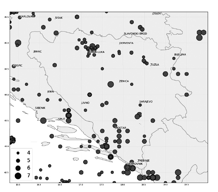
Figure 1. Significant historical earthquakes in the region (since 15th century)
Source: Adapted from the information by (Jozinovic, 2018) and (Markusic, 2008)
Most of these episodes have left considerable damage and is estimated that the magnitude was above 6 on the Richter’s scale. However it is the earthquakes from the 17th century that have left profound marks on Sarajevo and the city-state of Dubrovnik. A considerable damage to the urban core, had also considerable impact on the social order for many important members of the society have been incapacitated, including the Rector of Dubrovnik and in turn had profound impact on the relations between the Adriatic Republics (Venice and Ragusa), as well as the Ottoman Empire (Kuncevic & Madunic, 2015). Therefore, it is a fair assessment to state that the likelihood of a potentially devastating earthquake is a reality and that it could have far-reaching consequences beyond the destruction of physical infrastructure alone. During the collapse of Dubrovnik / Republic of Ragusa in 1667, Ottoman Empire, Venetian Republic and the Kingdom of Spain nearly came to full blows over who will control the devastated city; modern-day parables are not out of the question.
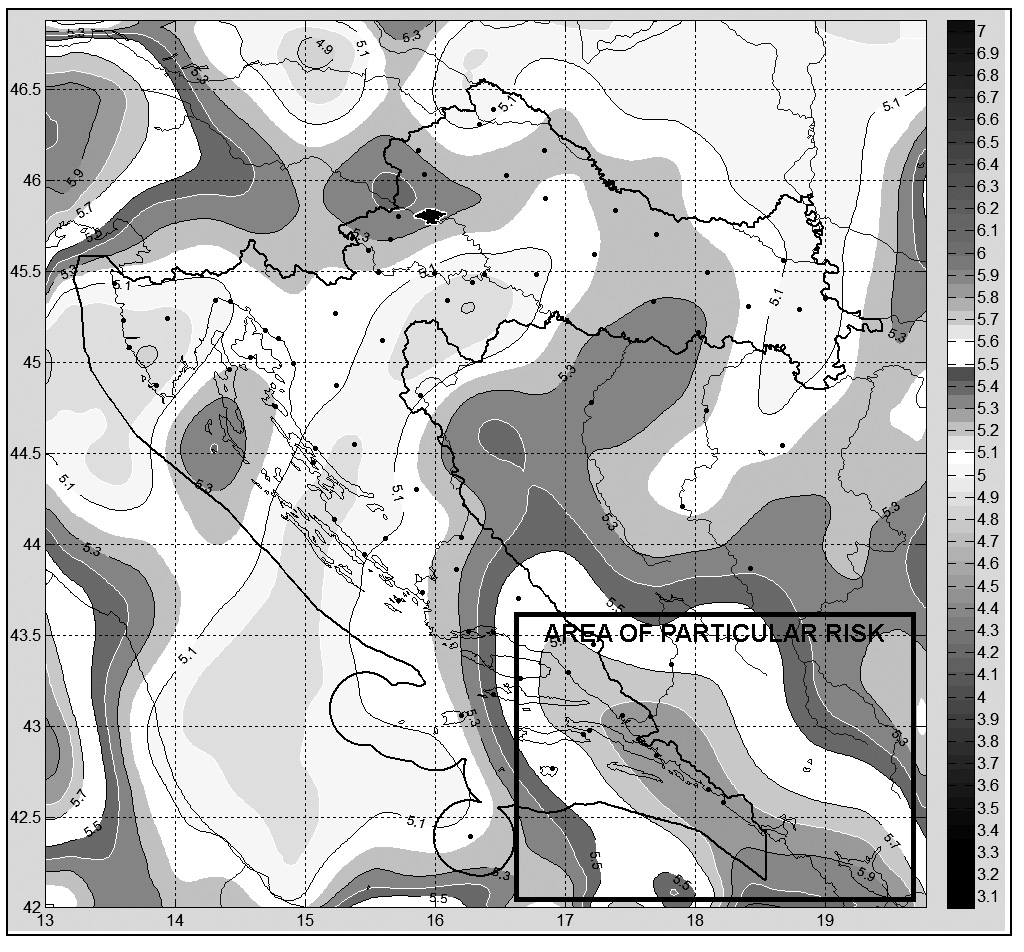
Figure 2. Recalculated models for seismic risk in Bosnia-Herzegovina and Croatia
Source: Adapted from (Herak, 2015)
3. Current Challenges
Following the series of strong and destructive earthquakes in former Yugoslavia (Skopje, Macedonia 1963; Banja Luka, Bosnia-Herzegovina , 1969; Budva, Montenegro, 1979) there was a demonstrable need to revise existing building practices and codes. Majority of the reinforced concrete bearing system have been built under the provisions of seismic regulations from 1964 (aftermath of Skopje) and 1981 (Montenegro), and can be considered as modern method of construction in terms of the scientific (seismic, geotechnical, geo-mechanical etc.) knowledge of this period (Kalman-Spos & Hadzima-Nyarko, 2018). Since independence, Croatia has followed majority of the building practices as mandated by the ascendancy to EU and most of the buildings built in the last decade are in accordance with Eurocode-8 provisions for earthquake-resistant design (however, that is only 4% of all of the buildings). Situation in Bosnia-Herzegovina is a bit more complicated, for many urban areas have sustained considerable damage during the 1992-95 hostilities and in the subsequent reconstruction, rebuilding or stabilization, might have compromised the inherent structural integrity of the existing buildings (Ibrahimbegovic & Zlatar, 2008). As an additional element of complication, many of the post-war buildings or houses have been constructed under questionable licensing, acceptance or quality, especially in the suburban areas with very few of them having adequate hardening or reinforcement (Ademovic, Oliveira, & Lourenco, 2019).
Current state of the overall infrastructure in Southern Croatia / Bosnia-Herzegovina is also reason to some concern. Given the coherent national transportation strategy, Croatia has managed to improve and develop land, air and to an extent maritime transportation, whereas Bosnia-Herzegovina is considerably lacking in all regards. In the southern areas, especially in the zones of the largest seismic risk, the road network in Bosnia-Herzegovina (and particularly in the RS entity) is aging and in poor condition with many roads, cuts, tunnels rated “poor” or “unsatisfactory” and in severe need of maintenance (European Commission, 2019). The entire zone of seismic risk is served by only one functional airport (Mostar), which, if it survives major damage would be the only possible source to airlift the required material if the major roads are blocked with cave-ins or landslides. On the Croatian side, there are airports in Dubrovnik, Split and Zadar, as well as several seaports that could be used to ferry in relief. In the case of a major earthquake, the main relief pivot will have to come from Croatia, albeit it may echo certain episodes from the war-time blockades where only about 1/5th of relief supplies reached Bosnia-Herzegovina upon off-loading in Croatia, while the City of Mostar remains much-divided up to the present day (ICTY, 2017).
Given the possibility of significant seismic events (Herak, 2015) coupled with poor infrastructure and complex socio-political environment and sensibilities, the region may experience a devastating and long-lasting crisis with a very slow and painful recovery process.
4. Scenarios
The scenarios created within this study take into consideration a fictional magnitude 7+ Richter-scale event centered in the southern border region between Bosnia and Croatia in the Neretva River Valley and the series of secondary events that could exacerbate the crisis. As a part of every successful crisis-management, it is required to continuously test and “war-game” the various scenarios. The main goal for the scenarios is to provide food-for-thought and planning and taking into consideration some variables that are unique for the region.
4.1 Scenario: Landslides of March
Prologue: Rapid snow-melt and series of spring rains have increased water-levels throughout Herzegovina and Dalmatian hinterland. All tributaries of the Adriatic watershed are flowing at their maximum and some flooding is expected along river Neretva. Minor landslides and road-closures have been noted throughout the entire region and additional rainfall is in the forecast.
Event: At 0535 hours on March 15, a magnitude 7.2 Richter earthquake occurs approximately near the town of Pocitelj, some 30 kilometers south of Mostar, Bosnia-Herzegovina.
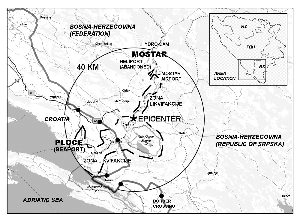
Figure 3. Scenario field map with the outlined epicenter and liquefaction zone
Source: Adapted from (Korajlic, Hodzic, Smailbegovic, & Toth, 2020)
Initial reports: The town of Pocitelj, mainly comprised of old, unreinforced stone houses is entirely destroyed. Partially completed highway bridge over Neretva river is sheared off, while the tunnels and landslides are blocking the southern route towards Croatia. Nearby towns of Capljina, Bosnia and Herzegovina and Metkovic, Croatia have also sustained heavy damage due to the liquefaction of water-saturated soils.
Regional outages: Mostar airport is knocked out of use due to liquefaction and bulging of the main runway; portions of the old helicopter base are still usable and may be used for helicopter operations. All roads leading to Mostar from the north have been cut-off by significant landslide. A portion of landslide has also compromised the dam at the Mostar hydroelectric plant and there are reports of channel forming on the eastern bank of Neretva River, which is already cresting at above-normal levels. City of Mostar has sustained considerable damage, especially in the old-quarter. Damages to the other town are unknown but estimated as significant.
Developments 1 (T+6 hours): Most of the power and regional communications have been knocked out in the wider region from Makarska, Croatia (west) to Dubrovnik, Croatia (east) and north to Mostar, Bosnia and Herzegovina . By 1000 hrs, additional rainfalls and aftershocks have blocked most of the north-south and east-west communication and bad weather hampers any airborne assessment. In Croatia, the seaport of Ploce is knocked out by the partial collapse of the pier and downing of the cranes. By noon, Croatia has mobilized first teams from Split and Dubrovnik to assess the level of damage on the coast and hinterland. In Bosnia-Herzegovina, Mostar and most of the Herzegovina region is cut off from each other; there are reports of barricades placed on the bridges between East and West Mostar to “discourage looting.” There is no concentrated effort underway to assess the damage. As the rainfall continues, Neretva river is rising against the Eastern bank of the hydroelectric dam; the likelihood of it breaching the dam are increasing.
Developments 2 (T+12 hours): Croatia reports considerable damage and requirement for additional resources in dealing with the destruction in Ploce and Metkovic. Residents of Capljina, Bosnia-Herzegovina and other towns are seeking help from Croatia, however overwhelmed as is, Croatia closes the border towards Bosnia-Herzegovina. All of the teams dispatched from Sarajevo to Mostar have not been able to come through due to several cave-ins along the main and secondary corridors; it is estimated that it will require at least 72 hours to clear the secondary or ternary roads towards Mostar. The situation in Mostar deteriorates as there is a virtual blockade between the eastern and western side, while the situation at the hydroelectric dam becomes dire as the additional rainfall is expected in the area.
Developments 3 (T+18 hours): The temperatures are falling and the situation is deteriorating at the border with Croatia as more residents are seeking assistance from Croatia; Croatia dispatches military forces at the border. A large volume of water had crested over the eastern portion of the Mostar Dam and spilled down towards the City of Mostar, destroying the damaged bridges and flooding majority of the Mostar Field. The floodwaters are expected to reach and flood the damaged towns downstream in Croatia.
Developments 4 (T+24 hours): The floods have brought additional devastation to the communities in Mostar and south of Mostar towards Adriatic Sea further complicating any efforts to clear the rubble or provide shelters. The cold-front is expected to bring freezing temperatures, which will present additional problems to the survivors. All medical facilities are either destroyed, unreachable or overwhelmed with the number of injured. Croatia border closure had collapsed in the wake of the floods and now there is a wide relief gap from Metkovic to Neretva estuary. The Government of Bosnia-Herzegovina had requested assistance from EUFOR and first helicopters are expected to set-up an emergency headquarters at the old Mostar helicopter base (Heliodrom). Meanwhile, Government of the Republic of Srpska stated that they will not wait for Sarajevo, but had requested assistance from Serbia and the Center for Humanitarian Assistance of the Russian Federation in Nis to assist communities in Trebinje and Gacko (RS Entity), Bosnia and Herzegovina. NATO command in Brussels issued a brief statement that it will not tolerate the deployment of the “Russian Humanitarians” under any circumstances.
4.2 Scenario: Cavtat Tsunami
Prologue: Dubrovnik Riviera is having an excellent tail-end of the tourist season with an estimated 300,000 tourists scattered along the Riviera. A large number of cruise ships, tourist vessels and private yachts are moored in the Dubrovnik Aquatorium while the airport is logging take-offs and landing every twenty minutes.
Event: At 2035 hours on August 22nd, a magnitude 7.4 Richter earthquake is recorded in the sea between Dubrovnik and Cavtat near island of Supetar; the shaking that continued for nearly 2 minutes resulted in an underwater cavitation and rupture extending towards the beachfront town of Kupari.
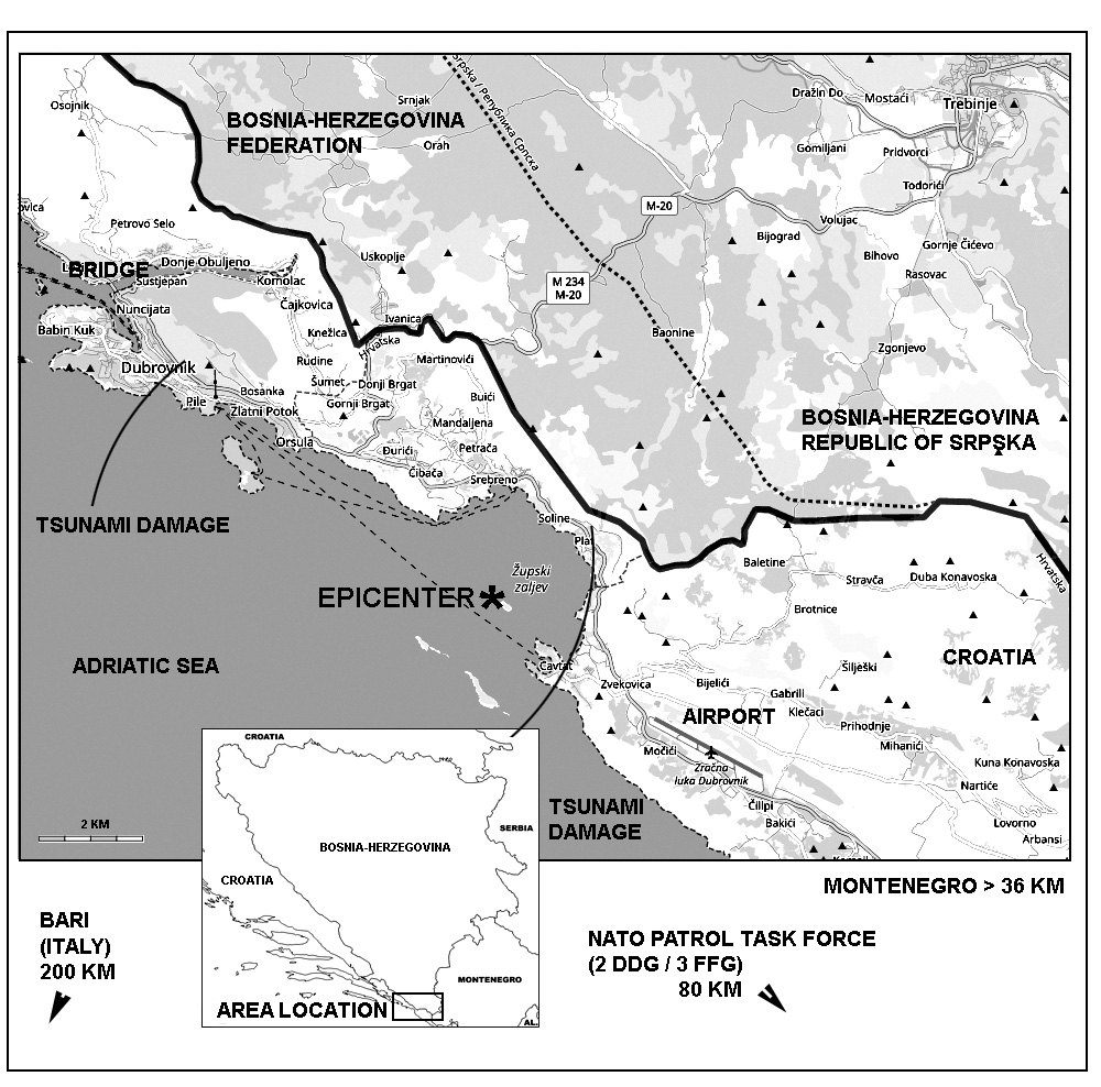
Figure 4. Scenario map for the earthquake / tsunami event in the Adriatic Sea
Source: Adapted from (Korajlic, Hodzic, Smailbegovic, & Toth, 2020)
Initial reports: City of Cavtat has been heavily damaged and many of the ships moored within the cove have been overturned by the 6m high “tsunami” wave that broke along the eastern side of the cove and then proceeded towards the Old-town Dubrovnik. Old town-Dubrovnik had sustained considerable damage and several cruise ships anchored between the island of Lokrum and the old-port have capsized. Port of Gruz is currently out of action and there are landslides and damages to the crown of the bridge on the main arterial road above the City of Dubrovnik. All electricity and other communications have been knocked out.
Regional outages: Dubrovnik Airport at Cilipi is knocked out due to the collapse of the runway along previously unknown cavern systems. There are reported fires in the Dubrovnik powerplant and along the powerlines in the Konavle region. Across the border, City of Trebinje, Bosna-Herzegovina and City of Herceg Novi in Montenegro have both sustained heavy damage. The combination of earthquake and the small tsunami had completely devastated the coastal communities of Mlini, Srebreno and Kupari. All road communications have been cut off by the rockfalls.
Developments 1 (T+6 hours): Available land-crews are clearing the rubble in Dubrovnik, but the real drama is occurring in the sea, where numerous vessels have capsized, some of them with over 10,000 souls on board, while the “tsunami” had pulled considerable people from the shore into the sea. All available ships are trying to rescue any survivors in the complete darkness and smoke from the nearby wildfires. Croatia has dispatched any available aircraft and ships to aid in the rescue efforts, however dense smoke and darkness are bound to present additional problems. Italy has also dispatched several ships and rescue aircraft and several NATO ships in Adriatic are also rushing to the scene. In Bosnia-Herzegovina there is a complete devastation of the City of Trebinje and potential damage to the Grancarevo hydroelectric dam. There are also noted wildfires throughout the wooded mountains. In Montenegro, there is a considerable damage along all of the communities bounding the Bay of Kotor, however there are no road closures or capsized vessels.
Developments 2 (T+12 hours): The daybreak had revealed a full-scale devastation, which mainly occurred on the sea and along the coastal communities which have experienced the damage from shaking, liquefaction and tsunami impact. Large number of overturned vessels have sunk and some of the fuel had ignited; coupled with the smoke from the fires, it is creating a significant smoke screen above the water hampering rescue efforts from the air. It is estimated that nearly 30,000 people might have drowned as a result of sinking vessels and shoreline tsunami impact. The number of casualties beneath collapsed buildings in Cavtat and Dubrovnik is unknown, however the attenuating factor was the majority of people were outside when the disaster struck, minimizing the number of individuals under the rubble. Most of the road-communications are still being cleared. Situation in Bosnia-Herzegovina is somewhat chaotic as the Government of the entity of Republic of Srpska is blocking any aid and assessment from the Federation entity; the convoys from the Federal Agency for Civil Defense are stopped at the administrative line with the RS entity. There was a reported explosion at the Gacko coal-fired power plant, but no additional reports are available.
Developments 3 (T+18 hours): An emergency command center was established on an empty gas-tanker moored between Dubrovnik and Cavtat and capable of operating two helicopter landing sites; majority of the helicopters are operating from the portion of the Dubrovnik Cilipi Airport or Konavle Field, some 30 km southeast. Operations on the sea-recovery are continuing while some of the air assets are tasked towards fire-fighting. Several NATO ships have arrived on station and are assisting with their crew, landing decks and aircraft in the variety of operations in Croatia and Montenegro. The arrival of land-aid from Croatia is being made possible by using available ferry fleet to move the trucks from Peljesac Peninsula to the Port of Gruz. Meanwhile in Bosnia-Herzegovina, EUFOR landed 6 helicopters in Trebinje and Gacko only to discover Russian forces already setting up command posts; the commander of the Humanitarian Assistance Corps Air Mobility Brigade of the Russian Federation has politely asked EUFOR to leave the area immediately for their services are no longer needed.
5. Discussion
The scenarios presented take into consideration some extreme circumstance that could be expected during and in the aftermath of an earthquake. The past experience shows that one disaster is often followed and exacerbated by other events, and given the complex socio-political environment of the area, it is to be expected. Based on the lessons learned from the crises and their effective post-mortem analysis (Kesetovic, Korajlic, & Toth, 2013), and especially in the light of their immediate environment in the Western Balkans, as demonstrated during the floods of 2010 (Sava Watershed Agency, 2010) all crises are expected to escalate due to slow response and complicated political/administrative system. There is a considerable level of institutional paralysis notable, especially in Bosnia-Herzegovina, where the level of cross-coordination between the different administrative entities, agencies or municipalities are significantly lacking (European Commission, 2019).
The presented scenarios (Korajlic, Hodzic, Smailbegovic, & Toth, 2020) indicate how even in the light of devastating, fast-moving events, the lack of coordination and cooperation would likely hamper any initiative to assess the situation, resolve the immediate and cascading problems and move onto the recovery phase. The first 24 hours are particularly significant in any serious crisis, for the decisions and directions taken then are bound to set the overall tone of its successful resolution (Kesetovic, Korajlic, & Toth, 2013). More importantly, however is how developed is the crisis plan and how implementable the plan is in the real-world scenario. For example, the current natural disaster risk plan for Bosnia and Herzegovina (Federal administration of civil protection, 2014) is outlining majority of the risks that could be encountered in the Federation Entity, however it fails to address the certain realities on the ground, namely in the issues of interoperability and communication and is overly reliant on the “resources of the international community” to cover the shortcomings. More-less similar situation is encountered in the Republic of Srpska entity of Bosnia-Herzegovina and very little attention is given to interoperability and cooperation, with the majority of the responsibilities ending at the administrative border of RS (Zoric & Culibrk, 2017).
The situation within civil-defense and crisis-management and preparedness in Croatia had gone through several iterations and improvements, particularly in the light of entry into full NATO and EU membership (Parker, Persson, & Widmalm, 2019). Further, Croatia has fewer administrative barrier and its emergency-response is fairly centralized, however its main shortcomings are that it is top-heavy, relatively inert and lacking required resources to cover large swaths of its elongated territory, but it demonstrates considerable coordination of the crisis-management team (Ostojic, 2016).
The scenarios presented above suggest a cascading-level of events that may require out-of-the-box approach to solve (e.g. employing alternate command centers, taking command decision and relieving pressure spots, dealing with adverse conditions etc.), but the main goal is to demonstrate why cooperation and interoperability are crucial in resolving the situation. Bosnia-Herzegovina, Croatia and to an extent Montenegro form an interdependent block and could work on implementing streamlined cross-border crisis plans – especially as Croatia and Montenegro are full-fledged NATO members and Bosnia-Herzegovina is within NATO-MAP program (as of 2019).
There is also a political dimension in the proposed scenarios: just as the great powers of the 17th century were contending over their footholds in the Adriatic Sea, nowadays that competition is again in focus between NATO and increasingly assertive Russia and China. The recently inaugurated Russian-Serbian Humanitarian Center in Nis, Serbia (Dzhambazova, 2018) may be exactly the type of power projection and initiative-seizing as described in the scenarios above and “active measures” aimed against exacting leverage against EU and NATO (Galeotti, 2018) and that any crisis may be a “terrible thing to waste.”
5. Conclusion
The main goal of this paper is to initiate discussion in the professional crisis-management circles on how to properly address and plan for a crisis that can occur at the fault-line not only of seismo-tectonic provinces but also socio-political fault lines, within the country (Bosnia-Herzegovina), in former Yugoslavia (Bosnia-Herzegovina/Croatia/Montenegro) and wider area (EU/NATO/Russia/China). A potential major seismic event is not only going to severely weaken and test the physical realm, but may introduce further reaching political instability that may cripple and hamper any response scenarios even further. The history and geology are both indicative of the propensity for destruction, however lack of cooperation and effective management may prolong and amplify the effects of any natural disaster.
5. References
Ademovic, N., Oliveira, D., & Lourenco, P. (2019). Seismic Evaluation and Strengthening of an Existing Masonry Buildings in Sarajevo, BH. Buildings Vol. 9, 30;.
Dzhambazova, B. (2018, 11 27). In Serbia, a Former Military Base Finds a New Role. The New York Times.
European Commission. (2019). Analytical Report: Commission Opinion on Bosnia and Herzegovina’s application for membership of the. Brussels: European Commission.
European Commission. (2019). Expert Report on Rule of Law issues in Bosnia and Herzegovina. Brussels: European Commission.
Federal administration of civil protection. (2014). Risk assessment of Federation Bosnia and Herzegovina Regarding Natural and Other Disasters. 2014: Government of the Federation of Bosnia and Herzegovina.
Galeotti, M. (2018). Do the Western Balkans face a coming Russian storm; Policy Brief. Berlin: European Council on Foreign Relations (ECFR).
Herak, M. (2015). Compilation of Croatian Earthquake Hazard Maps. Zagreb: European Commission, Ellaboration of Maps for Climatic and Seismic Actions.
Ibrahimbegovic, A., & Zlatar, M. (2008). Damage Assessment and Reconstruction after War or Natural Disaster. Sarajevo, Bosnia and Herzegovina: Springer / NATO Public Diplomacy Division.
ICTY. (2017). Judgement Summary for Prlic et Al. Hague: United Nations.
Jozinovic, D. (2018). Povijesni potresi u Bosni i Hercegovini (Historical earthquakes in Bosnia and Herzegovina). Zagreb, Croatia: Thesis. University of Zagreb, Faculty of Natural Sciences and Mathematics, Geophysics Department.
Kalman-Spos, T., & Hadzima-Nyarko, M. (2018). Seismic Risk of Croatian Cities Based on Building’s Vulnerability. Technical Gazette 25, 4, 1088-1094.
Kesetovic, Z., Korajlic, N., & Toth, I. (2013). Krizni Menadzment (Crisis Management). Sarajevo / Velika Gorica: Univerzitet u Sarajevu, BiH i Veleuciliste Vilka Gorica, Hrvatska.
Korajlic, N., Hodzic, K., Smailbegovic, A., & Toth, I. (2020). Praktikum za Krizni Menadzment (Workbook for Crisis Management). Sarajevo: University of Sarajevo.
Kuncevic, L., & Madunic, D. (2015). Venice and Dubrovnik During the Great Earthquake of 1667. Dubrovnik annals, No. 19,, 7-56.
Markusic, S. (2008). Seismicity of Croatia. Earthquake Monitoring and Seismic Hazard Mitigation in Balkan Countries, 79-96.
Ostojic, R. (2016). A European Perspective of the Migration Crisis: Croatian Experiences. Zagreb: Politik Fur Europa 2017-plus.
Parker, C., Persson, T., & Widmalm, S. (2019). The effectiveness of national and EU-level civil protection systems: evidence from 17 member states. Journal of European Public Policy, Vol. 26, Issue 9, 1312-1334.
Sava Watershed Agency. (2010). Voda i mi (Water and us) Vol. 14, No. 70. Sarajevo: Agencija za vodno podrucje rijeke Save.
Stiros, S. (2019). Intensities of ancient earthquakes, earthquake magnitude and soil dynamics effects. Evidence from the 1750 Croatia earthquake. Geodesy and Geodynamics, Vol. 10, Issue 4, 339-345.
Tari, V. (2002). Evolution of the northern and western Dinarides:. EGU Stephan Mueller Special Publication Series, Vol. 1, 223-236.
Yeats, R. S. & Prentice, R. Y. (1996). Introduction to special section: paleoseismology. Jour. Geophys. Res., 101 (B3), 5847-5853.
Zoric, Z., & Culibrk, Z. (2017). Civilna Zastita u Bosni i Hercegovinu kroz prizmu institucionalne teorije organizacije. Vojno Delo Vol. 7, 78-86.
